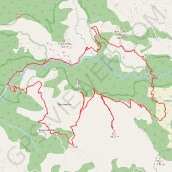
Gornja Trešnjica
- Distance: 14.2 mi
- Elevation gain: 3,973 ft
- Maximum elevation: 3,297 ft
- Elevation loss: 3,976 ft
- Minimum elevation: 764 ft
- Moving time: 6 h 20 m
- Moving speed: 2.2 mph
- Maximum speed: 4.6 mph
- Total time: 7 h 58 m
- Global speed: 1.8 mph
Interactive trail map
Trail profile
- Distance: 14.2 mi
- Elevation gain: 3,973 ft
- Maximum elevation: 3,297 ft
- Elevation loss: 3,976 ft
- Minimum elevation: 764 ft
- Moving time: 6 h 20 m
- Moving speed: 2.2 mph
- Maximum speed: 4.6 mph
- Total time: 7 h 58 m
- Global speed: 1.8 mph
About this trail
Name: Gornja Trešnjica trail, distance, elevation, map, profile, GPS track
Coordinates: 44.12193 19.51779 44.14984 19.56957
Other hiking, mountain biking, running and outdoor activity trails
Click on a trail to view its statistics, map and profile.
2022_Yu
Slovenia > Ajdovščina > Žapuže
Distance: 1,526.9 mi • Elevation gain: 105,144 ft • Maximum elevation: 6,398 ft
Trešnjica : Klisura rijeke Trešnjice, selo Košlje i okolina
Serbia > Central Serbia > Macva Administrative District > Ljubovija Municipality > Grcic
Distance: 8.6 mi • Elevation gain: 2,507 ft • Maximum elevation: 2,697 ft
Kanjon Trešnjica- Trešnjica - gornje Košlje
Serbia > Central Serbia > Macva Administrative District > Ljubovija Municipality > Grcic
Distance: 9.0 mi • Elevation gain: 2,582 ft • Maximum elevation: 2,697 ft
Gornje Koslje - Tresnjica Gorge - Dubrasnica Waterfall - Pos...
Serbia > Central Serbia > Macva Administrative District > Ljubovija Municipality > Gornje Koslje
Distance: 7.6 mi • Elevation gain: 2,070 ft • Maximum elevation: 3,009 ft