Thank you for supporting this site ❤️
Make a donation
Make a donation
Gear up for your next adventure:
As an Amazon Associate, this site earns from qualifying purchases at no extra cost to you.
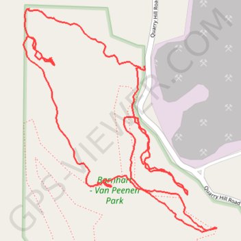
Barnhart - Van Peenen Park Loop
- Distance: 2.1 mi
- Elevation gain: 194 ft
- Maximum elevation: 1,119 ft
- Elevation loss: 194 ft
- Minimum elevation: 1,030 ft
- Moving time: 51 m 17 s
- Moving speed: 2.5 mph
- Maximum speed: 5.3 mph
- Total time: 1 h 10 m
- Global speed: 1.8 mph
Interactive trail map
Thank you for supporting this site ❤️
Make a donation
Make a donation
Gear up for your next adventure:
As an Amazon Associate, this site earns from qualifying purchases at no extra cost to you.
Trail profile
- Distance: 2.1 mi
- Elevation gain: 194 ft
- Maximum elevation: 1,119 ft
- Elevation loss: 194 ft
- Minimum elevation: 1,030 ft
- Moving time: 51 m 17 s
- Moving speed: 2.5 mph
- Maximum speed: 5.3 mph
- Total time: 1 h 10 m
- Global speed: 1.8 mph
Thank you for supporting this site ❤️
Make a donation
Make a donation
Gear up for your next adventure:
As an Amazon Associate, this site earns from qualifying purchases at no extra cost to you.
About this trail
Name: Barnhart - Van Peenen Park Loop trail, distance, elevation, map, profile, GPS track
Start: The Prarie, Winneshiek County, Iowa, 52101, United States (43.31890 -91.77329)
End: The Prarie, Winneshiek County, Iowa, 52101, United States (43.31885 -91.77343)
Coordinates: 43.31444 -91.77775 43.32043 -91.77061
Topography: Winneshiek County topographic map, elevation, terrain
Thank you for supporting this site ❤️
Make a donation
Make a donation
Gear up for your next adventure:
As an Amazon Associate, this site earns from qualifying purchases at no extra cost to you.