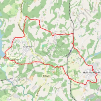
Ardingly, Horstead Keynes
- Distance: 11.3 mi
- Elevation gain: 1,224 ft
- Maximum elevation: 436 ft
- Elevation loss: 1,220 ft
- Minimum elevation: 135 ft
- Moving time: 4 h 26 m
- Moving speed: 2.5 mph
- Maximum speed: 5.0 mph
- Total time: 5 h 30 m
- Global speed: 2.1 mph
Interactive trail map
Trail profile
- Distance: 11.3 mi
- Elevation gain: 1,224 ft
- Maximum elevation: 436 ft
- Elevation loss: 1,220 ft
- Minimum elevation: 135 ft
- Moving time: 4 h 26 m
- Moving speed: 2.5 mph
- Maximum speed: 5.0 mph
- Total time: 5 h 30 m
- Global speed: 2.1 mph
About this trail
Name: Ardingly, Horstead Keynes trail, distance, elevation, map, profile, GPS track
Start: North Quad, Ardingly, Mid Sussex, West Sussex, England, RH17 6SQ, United Kingdom (51.04226 -0.09706)
End: North Quad, Ardingly, Mid Sussex, West Sussex, England, RH17 6SQ, United Kingdom (51.04234 -0.09673)
Coordinates: 51.02924 -0.09782 51.06335 -0.02389
Other hiking, mountain biking, running and outdoor activity trails
Click on a trail to view its statistics, map and profile.
Walk - Danehill, Chelwood Gate, Birchgrove, Horsted Keynes
United Kingdom > England > East Sussex > Wealden > Danehill
Danehill, Chelwood Gate, Birchgrove, Horsted Keynes
Distance: 9.9 mi • Elevation gain: 1,129 ft • Maximum elevation: 515 ft
Walk - Danehill, Horsted Keynes
United Kingdom > England > East Sussex > Wealden > Danehill
Distance: 7.8 mi • Elevation gain: 745 ft • Maximum elevation: 387 ft
Loop walk around Balcome including Ardingly Reservoir
United Kingdom > England > West Sussex > Mid Sussex > Balcombe
Balcombe, West Sussex, UK
Distance: 6.9 mi • Elevation gain: 630 ft • Maximum elevation: 348 ft
Ardingly Reservoir to Wakehurst Place walk
United Kingdom > England > West Sussex > Mid Sussex > Ardingly
Distance: 5.0 mi • Elevation gain: 335 ft • Maximum elevation: 463 ft
Loop Walk between Scaynes Hill and Horsted Keynes
United Kingdom > England > West Sussex > Mid Sussex > Scaynes Hill
Distance: 11.3 mi • Elevation gain: 840 ft • Maximum elevation: 328 ft
Loop Walk - Danehill, Chelwood Gate, Birchgrove, Horsted Keynes
United Kingdom > England > East Sussex > Wealden > Danehill
Distance: 11.1 mi • Elevation gain: 1,237 ft • Maximum elevation: 515 ft
Loop walk - Ardingly Reservoir, Balcombe, Wakehurst Place, Ardingly
United Kingdom > England > West Sussex > Mid Sussex > Ardingly
Distance: 10.4 mi • Elevation gain: 1,079 ft • Maximum elevation: 466 ft
Loop walk via Ardingly Reservoir, Wakehurst Place and Balcombe
United Kingdom > England > West Sussex > Mid Sussex > Ardingly
Distance: 9.1 mi • Elevation gain: 761 ft • Maximum elevation: 456 ft
Walk - Ardingly Reservoir, Balcombe, Wakehurst Place
United Kingdom > England > West Sussex > Mid Sussex > Ardingly
Ardingly Reservoir, Balcombe, Wakehurst Place
Distance: 9.1 mi • Elevation gain: 1,010 ft • Maximum elevation: 463 ft
Walk - Horsted Keynes, Danehill, Heaven Farm
United Kingdom > England > West Sussex > Mid Sussex > Horsted Keynes
Distance: 8.1 mi • Elevation gain: 925 ft • Maximum elevation: 410 ft
Walk between Scaynes Hill and Horsted Keynes
United Kingdom > England > West Sussex > Mid Sussex > Scaynes Hill
Distance: 9.8 mi • Elevation gain: 827 ft • Maximum elevation: 305 ft
Walk - Ardingly, West Hoathly, Horsted Keynes
United Kingdom > England > West Sussex > Mid Sussex > Ardingly
Distance: 11.7 mi • Elevation gain: 1,339 ft • Maximum elevation: 597 ft
Walk - Ardingly Reservoir, Horsted Keynes
United Kingdom > England > West Sussex > Mid Sussex > Ardingly
Distance: 6.6 mi • Elevation gain: 932 ft • Maximum elevation: 436 ft
Loop Walk - Scaynes Hill, Horsted Keynes
United Kingdom > England > West Sussex > Mid Sussex > Scaynes Hill
Distance: 11.1 mi • Elevation gain: 843 ft • Maximum elevation: 328 ft
Walk - Balcombe, Ouse Valley, Ardingly
United Kingdom > England > West Sussex > Mid Sussex > Balcombe
Distance: 11.0 mi • Elevation gain: 997 ft • Maximum elevation: 427 ft
Ardingly to Horsted Keynes Loop Walk
United Kingdom > England > West Sussex > Mid Sussex > Ardingly
Distance: 9.6 mi • Elevation gain: 1,227 ft • Maximum elevation: 440 ft
Walk - Wakehurst Place, Loder Valley
United Kingdom > England > West Sussex > Mid Sussex > Ardingly
Distance: 4.7 mi • Elevation gain: 449 ft • Maximum elevation: 456 ft
Walk - Balcombe, Wakehurst, Ardingly
United Kingdom > England > West Sussex > Mid Sussex > Balcombe
Distance: 9.4 mi • Elevation gain: 892 ft • Maximum elevation: 459 ft
Walk - Scaynes Hill, Horsted Keynes
United Kingdom > England > West Sussex > Mid Sussex > Scaynes Hill
Distance: 11.1 mi • Elevation gain: 850 ft • Maximum elevation: 328 ft
Ardingly Reservoir Dam
United Kingdom > England > West Sussex > Mid Sussex > Horsted Keynes
Distance: 4.8 mi • Elevation gain: 315 ft • Maximum elevation: 325 ft