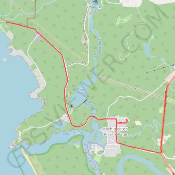
Ride from Sandy Beach
- Distance: 4.5 mi
- Elevation gain: 456 ft
- Maximum elevation: 810 ft
- Elevation loss: 282 ft
- Minimum elevation: 620 ft
Interactive trail map
Trail profile
- Distance: 4.5 mi
- Elevation gain: 456 ft
- Maximum elevation: 810 ft
- Elevation loss: 282 ft
- Minimum elevation: 620 ft
About this trail
Name: Ride from Sandy Beach trail, distance, elevation, map, profile, GPS track
Coordinates: 47.93263 -84.85339 47.95655 -84.80918
Other hiking, mountain biking, running and outdoor activity trails
Click on a trail to view its statistics, map and profile.
Wawa - Lake Superior Provincial Park
Canada > Ontario > Algoma District > Wawa
#Bike #Wawa #LakeSuperior
Distance: 55.5 mi • Elevation gain: 2,920 ft • Maximum elevation: 1,339 ft