Thank you for supporting this site ❤️
Make a donation
Make a donation
Gear up for your next adventure:
As an Amazon Associate, this site earns from qualifying purchases at no extra cost to you.
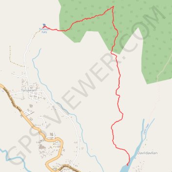
Tanawan-Davildavilan Trail
- Distance: 3.5 mi
- Elevation gain: 1,414 ft
- Maximum elevation: 2,635 ft
- Elevation loss: 2,441 ft
- Minimum elevation: 194 ft
- Moving time: 2 h 34 m
- Moving speed: 1.4 mph
- Maximum speed: 3.0 mph
- Total time: 4 h 31 m
- Global speed: 0.8 mph
Interactive trail map
Thank you for supporting this site ❤️
Make a donation
Make a donation
Gear up for your next adventure:
As an Amazon Associate, this site earns from qualifying purchases at no extra cost to you.
Trail profile
- Distance: 3.5 mi
- Elevation gain: 1,414 ft
- Maximum elevation: 2,635 ft
- Elevation loss: 2,441 ft
- Minimum elevation: 194 ft
- Moving time: 2 h 34 m
- Moving speed: 1.4 mph
- Maximum speed: 3.0 mph
- Total time: 4 h 31 m
- Global speed: 0.8 mph
Thank you for supporting this site ❤️
Make a donation
Make a donation
Gear up for your next adventure:
As an Amazon Associate, this site earns from qualifying purchases at no extra cost to you.
About this trail
Name: Tanawan-Davildavilan Trail trail, distance, elevation, map, profile, GPS track
Coordinates: 15.39645 121.37801 15.42242 121.39272
Thank you for supporting this site ❤️
Make a donation
Make a donation
Gear up for your next adventure:
As an Amazon Associate, this site earns from qualifying purchases at no extra cost to you.
Other hiking, mountain biking, running and outdoor activity trails
Click on a trail to view its statistics, map and profile.
Tanawan Falls
Philippines > Aurora > Dingalan > Tanawan
Distance: 0.2 mi • Elevation gain: 62 ft • Maximum elevation: 1,224 ft