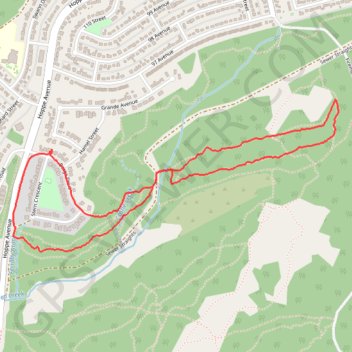
Grande Cache forest loop walk
- Distance: 2.5 mi
- Elevation gain: 266 ft
- Maximum elevation: 3,957 ft
- Elevation loss: 266 ft
- Minimum elevation: 3,822 ft
- Moving time: 1 h 46 s
- Moving speed: 2.5 mph
- Maximum speed: 4.9 mph
- Total time: 1 h 1 m
- Global speed: 2.5 mph
Interactive trail map
Trail profile
- Distance: 2.5 mi
- Elevation gain: 266 ft
- Maximum elevation: 3,957 ft
- Elevation loss: 266 ft
- Minimum elevation: 3,822 ft
- Moving time: 1 h 46 s
- Moving speed: 2.5 mph
- Maximum speed: 4.9 mph
- Total time: 1 h 1 m
- Global speed: 2.5 mph
About this trail
Name: Grande Cache forest loop walk trail, distance, elevation, map, profile, GPS track
Coordinates: 53.87430 -119.13916 53.88029 -119.11738
Other hiking, mountain biking, running and outdoor activity trails
Click on a trail to view its statistics, map and profile.
Grande Cache Old Canoe Viewpoint Loop via Great Escape, OG Rim Trail and Sulphur Slide
Canada > Alberta > Municipal District of Greenview > Hamlet of Grande Cache
Distance: 8.9 mi • Elevation gain: 1,490 ft • Maximum elevation: 3,973 ft
Great Escape, Rabbit's Foot, Shady Past, Old Canoe, Sulphur Slide and Creek 2 Peak loop trails
Canada > Alberta > Municipal District of Greenview > Hamlet of Grande Cache
Afternoon Mountain Bike Ride
Distance: 6.2 mi • Elevation gain: 702 ft • Maximum elevation: 4,003 ft
Grande Cache Ginger Princess and Bucksaw Ridge Loop Trail
Canada > Alberta > Municipal District of Greenview > Hamlet of Grande Cache
Distance: 6.9 mi • Elevation gain: 833 ft • Maximum elevation: 3,967 ft
Loop hike to Anton's Viewpoint
Canada > Alberta > Municipal District of Greenview > Hamlet of Grande Cache
Via Jumeau's Stretch, Hufflepuff, Phoenix, Cul de Sac, Hagrids, Mother Daughter Bonding, Fun Uncle Buck and Griffith trails.
Distance: 4.5 mi • Elevation gain: 869 ft • Maximum elevation: 3,980 ft
Grande Cache Loop Trail
Canada > Alberta > Municipal District of Greenview > Hamlet of Grande Cache
Distance: 6.1 mi • Elevation gain: 961 ft • Maximum elevation: 4,094 ft
Great Escape Loop Trail
Canada > Alberta > Municipal District of Greenview > Hamlet of Grande Cache
Distance: 5.3 mi • Elevation gain: 636 ft • Maximum elevation: 3,973 ft