Make a donation
Gear up for your next adventure:
As an Amazon Associate, this site earns from qualifying purchases at no extra cost to you.
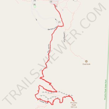
Picacho Peak via Hunter Trail in Picacho Peak State Park
The Hunter Trail to Picacho Peak offers a challenging yet rewarding hiking experience. As you ascend, you'll encounter steep switchbacks and sections requiring the use of fixed cables to navigate exposed rock faces. Upon reaching the summit, panoramic views of the Sonoran Desert, including expansive saguaro forests and distant mountain ranges, await. The trail is well-maintained, but hikers should be prepared for strenuous terrain and bring appropriate gear. #Hiking #Desert #Mountain #Nature
- Distance: 3.3 mi
- Elevation gain: 2,280 ft
- Maximum elevation: 3,120 ft
- Elevation loss: 2,283 ft
- Minimum elevation: 1,926 ft
- Moving time: 2 h 23 m
- Moving speed: 1.4 mph
- Maximum speed: 4.0 mph
- Total time: 4 h 10 m
- Global speed: 0.8 mph
Interactive trail map
Make a donation
Gear up for your next adventure:
As an Amazon Associate, this site earns from qualifying purchases at no extra cost to you.
Trail profile
- Distance: 3.3 mi
- Elevation gain: 2,280 ft
- Maximum elevation: 3,120 ft
- Elevation loss: 2,283 ft
- Minimum elevation: 1,926 ft
- Moving time: 2 h 23 m
- Moving speed: 1.4 mph
- Maximum speed: 4.0 mph
- Total time: 4 h 10 m
- Global speed: 0.8 mph
Make a donation
Gear up for your next adventure:
As an Amazon Associate, this site earns from qualifying purchases at no extra cost to you.
About this trail
Name: Picacho Peak via Hunter Trail in Picacho Peak State Park trail, distance, elevation, map, profile, GPS track
Start: Calloway Trail, Pinal County, Arizona, 85141, United States (32.64479 -111.40293)
End: Calloway Trail, Pinal County, Arizona, 85141, United States (32.64481 -111.40294)
Coordinates: 32.63477 -111.40516 32.64481 -111.40057
Topography: Pinal County topographic map, elevation, terrain
Make a donation
Gear up for your next adventure:
As an Amazon Associate, this site earns from qualifying purchases at no extra cost to you.
Other hiking, mountain biking, running and outdoor activity trails
Click on a trail to view its statistics, map and profile.