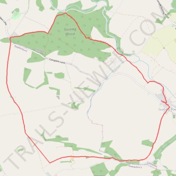
Guiting Power loop
- Distance: 7.7 mi
- Elevation gain: 659 ft
- Maximum elevation: 961 ft
- Elevation loss: 666 ft
- Minimum elevation: 584 ft
- Moving time: 2 h 59 m
- Moving speed: 2.6 mph
- Maximum speed: 5.0 mph
- Total time: 3 h 29 m
- Global speed: 2.2 mph
Interactive trail map
Trail profile
- Distance: 7.7 mi
- Elevation gain: 659 ft
- Maximum elevation: 961 ft
- Elevation loss: 666 ft
- Minimum elevation: 584 ft
- Moving time: 2 h 59 m
- Moving speed: 2.6 mph
- Maximum speed: 5.0 mph
- Total time: 3 h 29 m
- Global speed: 2.2 mph
About this trail
Name: Guiting Power loop trail, distance, elevation, map, profile, GPS track
Coordinates: 51.90925 -1.91942 51.94079 -1.86398
Other hiking, mountain biking, running and outdoor activity trails
Click on a trail to view its statistics, map and profile.
Dean2023-311
United Kingdom > England > Oxfordshire > Oxford
Distance: 192.8 mi • Elevation gain: 11,043 ft • Maximum elevation: 951 ft