Lissabon
name=Lissabon
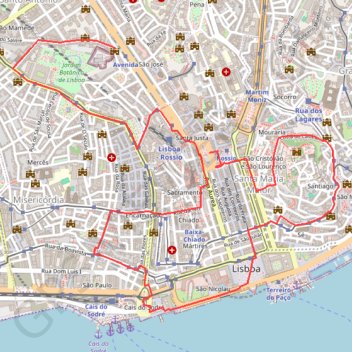
- Distance: 4.7 mi
- Elevation gain: 627 ft
- Maximum elevation: 272 ft
- Elevation loss: 699 ft
- Minimum elevation: -7 ft
Interactive trail map
Trail profile
- Distance: 4.7 mi
- Elevation gain: 627 ft
- Maximum elevation: 272 ft
- Elevation loss: 699 ft
- Minimum elevation: -7 ft
About this trail
Name: Lissabon trail, distance, elevation, map, profile, GPS track
Coordinates: 38.70541 -9.15244 38.71986 -9.13024
Other hiking, mountain biking, running and outdoor activity trails
Click on a trail to view its statistics, map and profile.
Camino Portugues Central
Portugal > Lisbon > Lisbon > Madalena
Lissabon - Porto: 347 km<br> Porto - Santiago: 242 km<br><br><a href="https://www.santiago.nl/product-categorie/gidsen/gidsen-portugal/">Gids</a><br>
Distance: 375.5 mi • Elevation gain: 27,198 ft • Maximum elevation: 1,542 ft
EuroVelo 1 (Por
Portugal > Viana do Castelo > Caminha > Terreiro
Distance: 718.6 mi • Elevation gain: 35,509 ft • Maximum elevation: 833 ft
01_BaixaChiado
Portugal > Lisbon > Lisbon > Misericórdia
Distance: 2.0 mi • Elevation gain: 272 ft • Maximum elevation: 190 ft