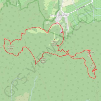
Vrsacke planine: Malo Središte - Man.Srediste - Guduricki vr...
- Distance: 9.2 mi
- Elevation gain: 2,707 ft
- Maximum elevation: 2,037 ft
- Elevation loss: 2,612 ft
- Minimum elevation: 600 ft
- Moving time: 4 h 50 m
- Moving speed: 1.9 mph
- Maximum speed: 3.3 mph
- Total time: 6 h 34 m
- Global speed: 1.4 mph
Interactive trail map
Trail profile
- Distance: 9.2 mi
- Elevation gain: 2,707 ft
- Maximum elevation: 2,037 ft
- Elevation loss: 2,612 ft
- Minimum elevation: 600 ft
- Moving time: 4 h 50 m
- Moving speed: 1.9 mph
- Maximum speed: 3.3 mph
- Total time: 6 h 34 m
- Global speed: 1.4 mph
About this trail
Name: Vrsacke planine: Malo Središte - Man.Srediste - Guduricki vr... trail, distance, elevation, map, profile, GPS track
Coordinates: 45.12698 21.36805 45.14726 21.41631
Other hiking, mountain biking, running and outdoor activity trails
Click on a trail to view its statistics, map and profile.
2022_Yu
Slovenia > Ajdovščina > Žapuže
Distance: 1,526.9 mi • Elevation gain: 105,144 ft • Maximum elevation: 6,398 ft