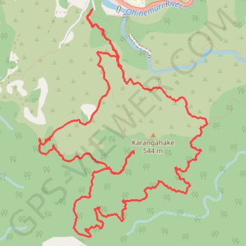
Karangahake Loop Mountain Biking
- Distance: 8.1 mi
- Elevation gain: 2,487 ft
- Maximum elevation: 1,759 ft
- Elevation loss: 2,497 ft
- Minimum elevation: 285 ft
- Moving time: 1 h 48 m
- Moving speed: 4.5 mph
- Maximum speed: 21.9 mph
- Total time: 2 h 21 m
- Global speed: 3.4 mph
Interactive trail map
Trail profile
- Distance: 8.1 mi
- Elevation gain: 2,487 ft
- Maximum elevation: 1,759 ft
- Elevation loss: 2,497 ft
- Minimum elevation: 285 ft
- Moving time: 1 h 48 m
- Moving speed: 4.5 mph
- Maximum speed: 21.9 mph
- Total time: 2 h 21 m
- Global speed: 3.4 mph
About this trail
Name: Karangahake Loop Mountain Biking trail, distance, elevation, map, profile, GPS track
Start: Number 7 Level Track, Karangahake, Hauraki District, Waikato, New Zealand (-37.42337 175.71787)
End: Number 7 Level Track, Karangahake, Hauraki District, Waikato, New Zealand (-37.42326 175.71803)
Coordinates: -37.44580 175.71131 -37.42321 175.73232