Thank you for supporting this site ❤️
Make a donation
Make a donation
Gear up for your next adventure:
As an Amazon Associate, this site earns from qualifying purchases at no extra cost to you.
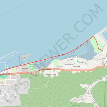
Astoria Riverwalk
- Distance: 3.3 mi
- Elevation gain: 43 ft
- Maximum elevation: 23 ft
- Elevation loss: 43 ft
- Minimum elevation: 0 ft
- Moving time: 1 h 39 m
- Moving speed: 2.0 mph
- Maximum speed: 3.3 mph
- Total time: 1 h 49 m
- Global speed: 1.8 mph
Interactive trail map
Thank you for supporting this site ❤️
Make a donation
Make a donation
Gear up for your next adventure:
As an Amazon Associate, this site earns from qualifying purchases at no extra cost to you.
Trail profile
- Distance: 3.3 mi
- Elevation gain: 43 ft
- Maximum elevation: 23 ft
- Elevation loss: 43 ft
- Minimum elevation: 0 ft
- Moving time: 1 h 39 m
- Moving speed: 2.0 mph
- Maximum speed: 3.3 mph
- Total time: 1 h 49 m
- Global speed: 1.8 mph
Thank you for supporting this site ❤️
Make a donation
Make a donation
Gear up for your next adventure:
As an Amazon Associate, this site earns from qualifying purchases at no extra cost to you.
About this trail
Name: Astoria Riverwalk trail, distance, elevation, map, profile, GPS track
Coordinates: 46.19420 -123.80331 46.20079 -123.77535
Topography: Clatsop County topographic map, elevation, terrain
Thank you for supporting this site ❤️
Make a donation
Make a donation
Gear up for your next adventure:
As an Amazon Associate, this site earns from qualifying purchases at no extra cost to you.