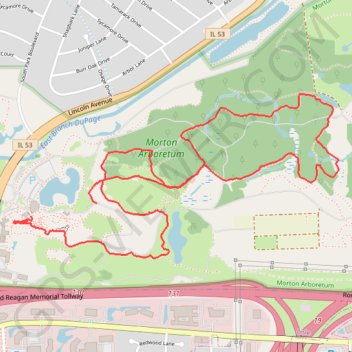
Arboretum has a new connector path
First light after main shingles sizzles ♨️. Super day!
- Distance: 4.1 mi
- Elevation gain: 161 ft
- Maximum elevation: 761 ft
- Elevation loss: 174 ft
- Minimum elevation: 682 ft
- Moving time: 1 h 24 m
- Moving speed: 2.9 mph
- Maximum speed: 7.7 mph
- Total time: 1 h 27 m
- Global speed: 2.8 mph
Interactive trail map
Trail profile
- Distance: 4.1 mi
- Elevation gain: 161 ft
- Maximum elevation: 761 ft
- Elevation loss: 174 ft
- Minimum elevation: 682 ft
- Moving time: 1 h 24 m
- Moving speed: 2.9 mph
- Maximum speed: 7.7 mph
- Total time: 1 h 27 m
- Global speed: 2.8 mph
About this trail
Name: Arboretum has a new connector path trail, distance, elevation, map, profile, GPS track
Coordinates: 41.81187 -88.07228 41.82000 -88.05065
Topography: DuPage County topographic map, elevation, terrain