Make a donation
Gear up for your next adventure:
As an Amazon Associate, this site earns from qualifying purchases at no extra cost to you.
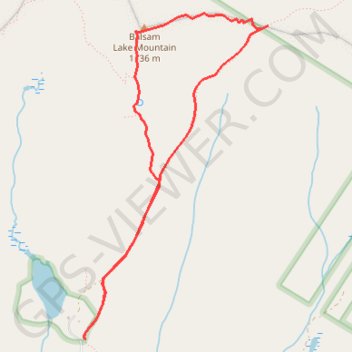
Balsam Lake Mountain Loop
Loop hike from Balsam Lake to Balsam Lake Mountain via Dry Brook Ridge Trail and Balsam Lake Mountain Trail in the Balsam Lake Mountain Wild Forest and the Cattskill Park. #Hiking #Loop #Mountain #Lake #Nature #Forest #Park
- Distance: 4.3 mi
- Elevation gain: 1,165 ft
- Maximum elevation: 3,717 ft
- Elevation loss: 1,168 ft
- Minimum elevation: 2,549 ft
- Moving time: 1 h 43 m
- Moving speed: 2.5 mph
- Maximum speed: 3.4 mph
- Total time: 1 h 50 m
- Global speed: 2.4 mph
Interactive trail map
Make a donation
Gear up for your next adventure:
As an Amazon Associate, this site earns from qualifying purchases at no extra cost to you.
Trail profile
- Distance: 4.3 mi
- Elevation gain: 1,165 ft
- Maximum elevation: 3,717 ft
- Elevation loss: 1,168 ft
- Minimum elevation: 2,549 ft
- Moving time: 1 h 43 m
- Moving speed: 2.5 mph
- Maximum speed: 3.4 mph
- Total time: 1 h 50 m
- Global speed: 2.4 mph
Make a donation
Gear up for your next adventure:
As an Amazon Associate, this site earns from qualifying purchases at no extra cost to you.
About this trail
Name: Balsam Lake Mountain Loop trail, distance, elevation, map, profile, GPS track
Coordinates: 42.02403 -74.59973 42.04691 -74.58229
Topography: Ulster County topographic map, elevation, terrain
Make a donation
Gear up for your next adventure:
As an Amazon Associate, this site earns from qualifying purchases at no extra cost to you.