Thank you for supporting this site ❤️
Make a donation
Make a donation
Gear up for your next adventure:
As an Amazon Associate, this site earns from qualifying purchases at no extra cost to you.
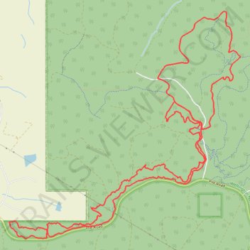
Wellington National Park MTB Ride: Boylan, Wals, Lennard Half Circuit and Grizzly loop
- Distance: 14.1 mi
- Elevation gain: 1,066 ft
- Maximum elevation: 1,063 ft
- Elevation loss: 1,066 ft
- Minimum elevation: 728 ft
- Moving time: 2 h 4 m
- Moving speed: 6.8 mph
- Maximum speed: 21.8 mph
- Total time: 2 h 32 m
- Global speed: 5.6 mph
Interactive trail map
Thank you for supporting this site ❤️
Make a donation
Make a donation
Gear up for your next adventure:
As an Amazon Associate, this site earns from qualifying purchases at no extra cost to you.
Trail profile
- Distance: 14.1 mi
- Elevation gain: 1,066 ft
- Maximum elevation: 1,063 ft
- Elevation loss: 1,066 ft
- Minimum elevation: 728 ft
- Moving time: 2 h 4 m
- Moving speed: 6.8 mph
- Maximum speed: 21.8 mph
- Total time: 2 h 32 m
- Global speed: 5.6 mph
Thank you for supporting this site ❤️
Make a donation
Make a donation
Gear up for your next adventure:
As an Amazon Associate, this site earns from qualifying purchases at no extra cost to you.
About this trail
Name: Wellington National Park MTB Ride: Boylan, Wals, Lennard Half Circuit and Grizzly loop trail, distance, elevation, map, profile, GPS track
Start: Boylan, Wellington Forest, Western Australia, 6236, Australia (-33.40521 115.86100)
End: Boylan, Wellington Forest, Western Australia, 6236, Australia (-33.40519 115.86111)
Coordinates: -33.40802 115.86100 -33.37026 115.90687
Thank you for supporting this site ❤️
Make a donation
Make a donation
Gear up for your next adventure:
As an Amazon Associate, this site earns from qualifying purchases at no extra cost to you.