Make a donation
Gear up for your next adventure:
As an Amazon Associate, this site earns from qualifying purchases at no extra cost to you.
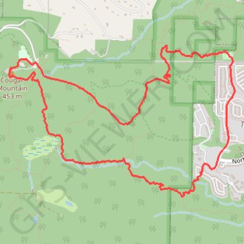
Cougar Mountain Loop
Loop hike to Cougar Mountain via Talus Bridge Trail, Bear Ridge Trail, West Tibbetts Creek Trail, Tibbetts Marsh Trail, Lost Beagle Trail, Southeast Cougar Mountain Drive, Shangri La Trail, No Name Trail, Surprise Creek Trail, Precipice Top Trail, Military Ridge Trail, Trearis Trail and Shangri-La Way Northwest in the Cougar Mountain Regional Wildland Park. #Hiking #Loop #Mountain #Nature #Forest #Park
- Distance: 5.3 mi
- Elevation gain: 1,175 ft
- Maximum elevation: 1,490 ft
- Elevation loss: 1,168 ft
- Minimum elevation: 381 ft
- Moving time: 2 h 52 m
- Moving speed: 1.8 mph
- Maximum speed: 7.2 mph
- Total time: 3 h 55 m
- Global speed: 1.3 mph
Interactive trail map
Make a donation
Gear up for your next adventure:
As an Amazon Associate, this site earns from qualifying purchases at no extra cost to you.
Trail profile
- Distance: 5.3 mi
- Elevation gain: 1,175 ft
- Maximum elevation: 1,490 ft
- Elevation loss: 1,168 ft
- Minimum elevation: 381 ft
- Moving time: 2 h 52 m
- Moving speed: 1.8 mph
- Maximum speed: 7.2 mph
- Total time: 3 h 55 m
- Global speed: 1.3 mph
Make a donation
Gear up for your next adventure:
As an Amazon Associate, this site earns from qualifying purchases at no extra cost to you.
About this trail
Name: Cougar Mountain Loop trail, distance, elevation, map, profile, GPS track
Coordinates: 47.52949 -122.09964 47.54246 -122.07108
Topography: King County topographic map, elevation, terrain
Make a donation
Gear up for your next adventure:
As an Amazon Associate, this site earns from qualifying purchases at no extra cost to you.
Other hiking, mountain biking, running and outdoor activity trails
Click on a trail to view its statistics, map and profile.
Northern part of the Pacific Crest Trail (PCT)
United States > Oregon > Klamath County
Hike on the Pacific Crest National Scenic Trail from Crater Lake to Canada Border through Oregon and Washington along the Sierra Nevada and Cascade mountain ranges. #Hiking #Mountain #SierraNevada #Cascade #Nature #Forest #Park #PCT
Distance: 744.6 mi • Elevation gain: 145,367 ft • Maximum elevation: 7,569 ft
Cougar Mountain Loop Hike
United States > Washington > King County > Renton > Coal Creek
Distance: 7.0 mi • Elevation gain: 1,234 ft • Maximum elevation: 1,493 ft