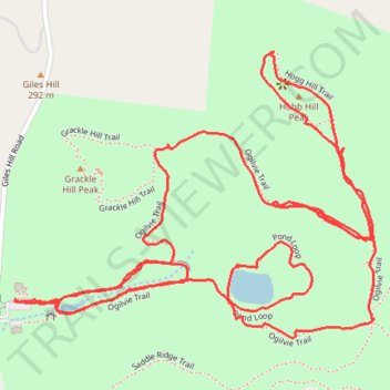
Trails at Peacock Hill Nature Park
- Distance: 3.2 mi
- Elevation gain: 469 ft
- Maximum elevation: 1,155 ft
- Elevation loss: 472 ft
- Minimum elevation: 866 ft
- Moving time: 1 h 15 m
- Moving speed: 2.6 mph
- Maximum speed: 5.2 mph
- Total time: 1 h 26 m
- Global speed: 2.3 mph
Interactive trail map
Trail profile
- Distance: 3.2 mi
- Elevation gain: 469 ft
- Maximum elevation: 1,155 ft
- Elevation loss: 472 ft
- Minimum elevation: 866 ft
- Moving time: 1 h 15 m
- Moving speed: 2.6 mph
- Maximum speed: 5.2 mph
- Total time: 1 h 26 m
- Global speed: 2.3 mph
About this trail
Name: Trails at Peacock Hill Nature Park trail, distance, elevation, map, profile, GPS track
Coordinates: 35.73581 -86.72173 35.74133 -86.71316
Topography: Williamson County topographic map, elevation, terrain
Other hiking, mountain biking, running and outdoor activity trails
Click on a trail to view its statistics, map and profile.
Peacock Hill Nature Park Trails loop
United States > Tennessee > Williamson County
Distance: 4.0 mi • Elevation gain: 633 ft • Maximum elevation: 1,155 ft
Gmaps Pedometer Route
United States > Kentucky > Fulton County > Hickman
Distance: 312.5 mi • Elevation gain: 13,793 ft • Maximum elevation: 1,942 ft