Mariposa Grove of Giant Sequoias Trail in Yosemite National Park
The Mariposa Grove of Giant Sequoias Trail offers a remarkable hiking experience through one of the largest and oldest groves of sequoia trees in Yosemite National Park. Starting from the Fallen Monarch, visitors are greeted by the impressive root system of this long-fallen sequoia. As you walk along the route, you'll encounter some of the park's most famous trees, including the towering Grizzly Giant, a majestic sequoia believed to be around 2,000 years old. Other notable sights include the California Tunnel Tree, where you can walk through a hollowed-out trunk, the unique Bachelor and Three Graces, a group of trees whose intertwined roots symbolize their deep connection, and the rare Faithful Couple Tree, where two trunks have fused together. The route concludes at Wawona Point, where panoramic views reward hikers with a sense of grandeur that matches the towering trees themselves. #Hiking #Forest #Nature #Overlook #Yosemite
- Distance: 6.9 mi
- Elevation gain: 1,220 ft
- Maximum elevation: 6,759 ft
- Elevation loss: 1,220 ft
- Minimum elevation: 5,663 ft
- Moving time: 2 h 23 m
- Moving speed: 2.9 mph
- Maximum speed: 5.7 mph
- Total time: 3 h 1 m
- Global speed: 2.3 mph
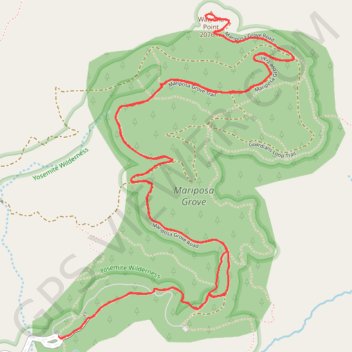
Interactive trail map
Trail profile
- Distance: 6.9 mi
- Elevation gain: 1,220 ft
- Maximum elevation: 6,759 ft
- Elevation loss: 1,220 ft
- Minimum elevation: 5,663 ft
- Moving time: 2 h 23 m
- Moving speed: 2.9 mph
- Maximum speed: 5.7 mph
- Total time: 3 h 1 m
- Global speed: 2.3 mph
About this trail
Name: Mariposa Grove of Giant Sequoias Trail in Yosemite National Park trail, distance, elevation, map, profile, GPS track
Start: Grove Arrival Area, Mariposa County, California, United States (37.50147 -119.61075)
End: Grove Arrival Area, Mariposa County, California, United States (37.50154 -119.61085)
Coordinates: 37.50143 -119.61085 37.51865 -119.59515
Topography: Mariposa County topographic map, elevation, terrain
Other hiking, mountain biking, running and outdoor activity trails
Click on a trail to view its statistics, map and profile.
Grizzly Giant Loop Trail in Yosemite National Park
United States > California > Mariposa County
The Grizzly Giant Loop Trail in Yosemite's Mariposa Grove offers a relatively short yet captivating hike through some of the world's most magnificent giant sequoias. Along the route, hikers will encounter the iconic Grizzly Giant, an awe-inspiring tree over 2,700 years old and nearly 30 feet wide at its base.…
Distance: 2.0 mi • Elevation gain: 387 ft • Maximum elevation: 5,984 ft
Wawona Point (Mariposa Grove)
United States > California > Mariposa County
Loop hike through Mariposa Grove to Wawona Point via Big Trees Trail, Fallen Monarch, Bachelor and Three Graces, Grizzly Giant, California Tunnel Tree, Telescope Tree, Fallen Tunnel Tree, Columbia Tree, Clothespin Tree and Faithful Couple Tree In Yosemite National Park. #Hiking #Loop #Mountain #Forest #Nature…
Distance: 6.4 mi • Elevation gain: 1,345 ft • Maximum elevation: 6,759 ft