Airport Mesa Viewpoint via Sedona View Trail in Coconino National Forest
The Sedona View Trail to Airport Mesa Viewpoint is a rewarding hike showcasing sweeping panoramas of Sedona’s vibrant red rock formations, including landmarks like Capitol Butte, Coffee Pot Rock, and Chimney Rock. The route combines accessible terrain with opportunities to observe juniper-dotted landscapes, moss-covered lava rocks, and unique vantage points over West Sedona and Oak Creek Canyon. Ideal for sunrise or sunset, the trail's beauty is complemented by its tranquil natural features, though proximity to the airport and occasional crowds may detract slightly from the serene atmosphere. #Hiking #Overlook #Forest #Nature
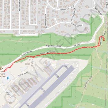
- Distance: 1.4 mi
- Elevation gain: 236 ft
- Maximum elevation: 4,810 ft
- Elevation loss: 233 ft
- Minimum elevation: 4,606 ft
- Moving time: 41 m 33 s
- Moving speed: 2.1 mph
- Maximum speed: 3.1 mph
- Total time: 54 m 6 s
- Global speed: 1.6 mph
Interactive trail map
Trail profile
- Distance: 1.4 mi
- Elevation gain: 236 ft
- Maximum elevation: 4,810 ft
- Elevation loss: 233 ft
- Minimum elevation: 4,606 ft
- Moving time: 41 m 33 s
- Moving speed: 2.1 mph
- Maximum speed: 3.1 mph
- Total time: 54 m 6 s
- Global speed: 1.6 mph
About this trail
Name: Airport Mesa Viewpoint via Sedona View Trail in Coconino National Forest trail, distance, elevation, map, profile, GPS track
Start: Shrine Road, Sedona, Yavapai County, Arizona, 86336, United States (34.85311 -111.78944)
End: Sedona View Trail, Sedona, Yavapai County, Arizona, 86336, United States (34.85315 -111.78923)
Coordinates: 34.85311 -111.78945 34.85609 -111.77910
Topography: Yavapai County topographic map, elevation, terrain