Toe approach
- Distance: 1.5 mi
- Elevation gain: 1,138 ft
- Maximum elevation: 1,703 ft
- Elevation loss: 23 ft
- Minimum elevation: 564 ft
- Moving time: 51 m 42 s
- Moving speed: 1.7 mph
- Maximum speed: 9.8 mph
- Total time: 1 h 34 m
- Global speed: 1.0 mph
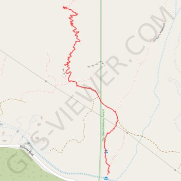
Interactive trail map
Trail profile
- Distance: 1.5 mi
- Elevation gain: 1,138 ft
- Maximum elevation: 1,703 ft
- Elevation loss: 23 ft
- Minimum elevation: 564 ft
- Moving time: 51 m 42 s
- Moving speed: 1.7 mph
- Maximum speed: 9.8 mph
- Total time: 1 h 34 m
- Global speed: 1.0 mph
About this trail
Name: Toe approach trail, distance, elevation, map, profile, GPS track
Start: Climber's Approach, San Diego County, California, United States (32.88556 -116.82314)
End: Toe Approach (climbing), San Diego County, California, United States (32.89665 -116.82633)
Coordinates: 32.88556 -116.82666 32.89667 -116.82231
Topography: San Diego County topographic map, elevation, terrain