Make a donation
Gear up for your next adventure:
As an Amazon Associate, this site earns from qualifying purchases at no extra cost to you.
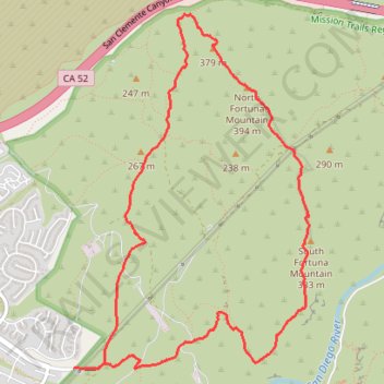
Fortuna Mountain Loop Trail in Mission Trails Regional Park
The Fortuna Mountain Loop Trail in Mission Trails Regional Park offers hikers expansive vistas of rolling hills and the vibrant San Diego cityscape. Along the route, the challenging ascent up South Fortuna's wooden steps, often dubbed the "Stairway to Heaven," provides both a physical test and rewarding panoramic views. Traversing diverse terrains, including serene oak-lined washes and open ridgelines, this loop immerses adventurers in the natural beauty characteristic of Southern California. #Hiking #Loop #Mountain #Overlook #Nature
- Distance: 6.3 mi
- Elevation gain: 1,371 ft
- Maximum elevation: 1,266 ft
- Elevation loss: 1,385 ft
- Minimum elevation: 364 ft
- Moving time: 2 h 17 m
- Moving speed: 2.8 mph
- Maximum speed: 3.9 mph
- Total time: 2 h 35 m
- Global speed: 2.4 mph
Interactive trail map
Make a donation
Gear up for your next adventure:
As an Amazon Associate, this site earns from qualifying purchases at no extra cost to you.
Trail profile
- Distance: 6.3 mi
- Elevation gain: 1,371 ft
- Maximum elevation: 1,266 ft
- Elevation loss: 1,385 ft
- Minimum elevation: 364 ft
- Moving time: 2 h 17 m
- Moving speed: 2.8 mph
- Maximum speed: 3.9 mph
- Total time: 2 h 35 m
- Global speed: 2.4 mph
Make a donation
Gear up for your next adventure:
As an Amazon Associate, this site earns from qualifying purchases at no extra cost to you.
About this trail
Name: Fortuna Mountain Loop Trail in Mission Trails Regional Park trail, distance, elevation, map, profile, GPS track
Coordinates: 32.82535 -117.07665 32.85260 -117.05518
Topography: San Diego topographic map, elevation, terrain
Make a donation
Gear up for your next adventure:
As an Amazon Associate, this site earns from qualifying purchases at no extra cost to you.
Other hiking, mountain biking, running and outdoor activity trails
Click on a trail to view its statistics, map and profile.