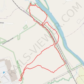
Mayo River State Park
- Distance: 2.0 mi
- Elevation gain: 157 ft
- Maximum elevation: 682 ft
- Elevation loss: 154 ft
- Minimum elevation: 545 ft
- Moving time: 55 m 11 s
- Moving speed: 2.1 mph
- Maximum speed: 4.7 mph
- Total time: 1 h 19 m
- Global speed: 1.5 mph
Interactive trail map
Trail profile
- Distance: 2.0 mi
- Elevation gain: 157 ft
- Maximum elevation: 682 ft
- Elevation loss: 154 ft
- Minimum elevation: 545 ft
- Moving time: 55 m 11 s
- Moving speed: 2.1 mph
- Maximum speed: 4.7 mph
- Total time: 1 h 19 m
- Global speed: 1.5 mph
About this trail
Name: Mayo River State Park trail, distance, elevation, map, profile, GPS track
Coordinates: 36.39563 -79.96606 36.40389 -79.95988
Topography: Rockingham County topographic map, elevation, terrain