Millard Falls
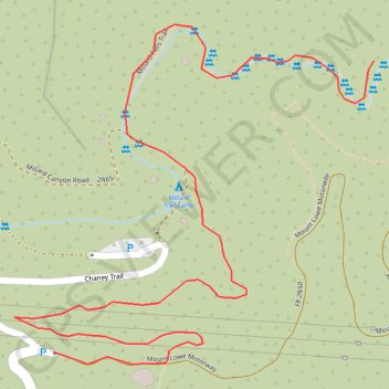
Interactive trail map
Trail profile
- Distance: 1.3 mi
- Elevation gain: 377 ft
- Maximum elevation: 2,142 ft
- Elevation loss: 308 ft
- Minimum elevation: 1,886 ft
About this trail
Name: Millard Falls trail, distance, elevation, map, profile, GPS track
Start: Chaney Trail, Altadena, Los Angeles County, California, 91001, United States (34.21478 -118.14757)
End: Millard Falls Trail, Los Angeles County, California, 91001, United States (34.21897 -118.14199)
Coordinates: 34.21460 -118.14825 34.21949 -118.14199
Topography: Los Angeles County topographic map, elevation, terrain
Other hiking, mountain biking, running and outdoor activity trails
Click on a trail to view its statistics, map and profile.
Gabrielino Trail
United States > California > Los Angeles County
Starting from Chantry Flat, the Gabrielino Trail slips from the shaded ridge above Big Santa Anita Canyon into a classic Angeles National Forest corridor of wooded slopes, creekside cabins and canyon-bottom shade. The route passes the lower canyon junctions, Cascade Picnic Area and Spruce Grove Trail Camp…
Distance: 27.6 mi • Elevation gain: 7,736 ft • Maximum elevation: 4,662 ft
Dawn Mine Loop via Sunset Ridge Trail in Angeles National Forest
United States > California > Los Angeles County > Altadena
The Dawn Mine Loop Trail in the Angeles National Forest offers hikers a diverse and rewarding experience. The journey begins with a shaded ascent through Millard Canyon, where the lush vegetation and occasional stream crossings provide a refreshing start. As you approach the historic Dawn Mine, the trail…
Distance: 5.4 mi • Elevation gain: 1,988 ft • Maximum elevation: 3,596 ft
Dawn Mine, Millard Creek and Millard Falls
United States > California > Los Angeles County
Distance: 2.6 mi • Elevation gain: 285 ft • Maximum elevation: 3,051 ft