Thank you for supporting this site ❤️
Make a donation
Make a donation
Gear up for your next adventure:
As an Amazon Associate, this site earns from qualifying purchases at no extra cost to you.
Newquay to Mawgan Porth
Interactive trail map
Thank you for supporting this site ❤️
Make a donation
Make a donation
Gear up for your next adventure:
As an Amazon Associate, this site earns from qualifying purchases at no extra cost to you.
Trail profile
- Distance: 15.5 mi
- Elevation gain: 2,388 ft
- Maximum elevation: 279 ft
- Elevation loss: 2,369 ft
- Minimum elevation: 0 ft
Thank you for supporting this site ❤️
Make a donation
Make a donation
Gear up for your next adventure:
As an Amazon Associate, this site earns from qualifying purchases at no extra cost to you.
About this trail
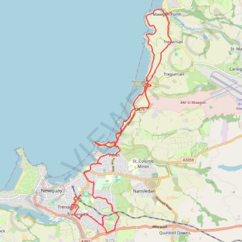
Name: Newquay to Mawgan Porth trail, distance, elevation, map, profile, GPS track
Coordinates: 50.40089 -5.07637 50.46628 -5.02967
Thank you for supporting this site ❤️
Make a donation
Make a donation
Gear up for your next adventure:
As an Amazon Associate, this site earns from qualifying purchases at no extra cost to you.
Other hiking, mountain biking, running and outdoor activity trails
Click on a trail to view its statistics, map and profile.
Newquay to Penhale Sands
United Kingdom > England > Cornwall > Newquay
Distance: 18.0 mi • Elevation gain: 2,333 ft • Maximum elevation: 289 ft