Make a donation
Gear up for your next adventure:
As an Amazon Associate, this site earns from qualifying purchases at no extra cost to you.
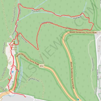
Musk loop
- Distance: 2.6 mi
- Elevation gain: 728 ft
- Maximum elevation: 1,247 ft
- Elevation loss: 719 ft
- Minimum elevation: 528 ft
- Moving time: 52 m 11 s
- Moving speed: 3.0 mph
- Maximum speed: 9.3 mph
- Total time: 1 h 5 m
- Global speed: 2.4 mph
Interactive trail map
Make a donation
Gear up for your next adventure:
As an Amazon Associate, this site earns from qualifying purchases at no extra cost to you.
Trail profile
- Distance: 2.6 mi
- Elevation gain: 728 ft
- Maximum elevation: 1,247 ft
- Elevation loss: 719 ft
- Minimum elevation: 528 ft
- Moving time: 52 m 11 s
- Moving speed: 3.0 mph
- Maximum speed: 9.3 mph
- Total time: 1 h 5 m
- Global speed: 2.4 mph
Make a donation
Gear up for your next adventure:
As an Amazon Associate, this site earns from qualifying purchases at no extra cost to you.
About this trail
Name: Musk loop trail, distance, elevation, map, profile, GPS track
Start: Tremont, Melbourne, Shire of Yarra Ranges, Victoria, 3785, Australia (-37.89185 145.31781)
Coordinates: -37.89250 145.31702 -37.88368 145.32734
Make a donation
Gear up for your next adventure:
As an Amazon Associate, this site earns from qualifying purchases at no extra cost to you.
Other hiking, mountain biking, running and outdoor activity trails
Click on a trail to view its statistics, map and profile.
Upper Ferntree Gully
Australia > Victoria > Melbourne
Upftg ride
Distance: 27.4 mi • Elevation gain: 5,194 ft • Maximum elevation: 1,736 ft
Upwey, Tremont Hill, One Tree Hill and Sherbrooke Falls loop
Australia > Victoria > Melbourne
Distance: 10.2 mi • Elevation gain: 2,257 ft • Maximum elevation: 1,722 ft
Dandenong Ranges National Park Ridgewalk
Australia > Victoria > Melbourne > Tremont
Distance: 13.7 mi • Elevation gain: 3,287 ft • Maximum elevation: 1,939 ft
Make a donation
Gear up for your next adventure:
As an Amazon Associate, this site earns from qualifying purchases at no extra cost to you.