Thank you for supporting this site ❤️
Make a donation
Make a donation
Gear up for your next adventure:
As an Amazon Associate, this site earns from qualifying purchases at no extra cost to you.
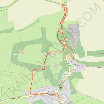
Permissive paths, Shorwell
- Distance: 1.4 mi
- Elevation gain: 256 ft
- Maximum elevation: 371 ft
- Elevation loss: 236 ft
- Minimum elevation: 180 ft
- Moving time: 27 m 49 s
- Moving speed: 3.0 mph
- Maximum speed: 6.0 mph
- Total time: 29 m 31 s
- Global speed: 2.8 mph
Interactive trail map
Thank you for supporting this site ❤️
Make a donation
Make a donation
Gear up for your next adventure:
As an Amazon Associate, this site earns from qualifying purchases at no extra cost to you.
Trail profile
- Distance: 1.4 mi
- Elevation gain: 256 ft
- Maximum elevation: 371 ft
- Elevation loss: 236 ft
- Minimum elevation: 180 ft
- Moving time: 27 m 49 s
- Moving speed: 3.0 mph
- Maximum speed: 6.0 mph
- Total time: 29 m 31 s
- Global speed: 2.8 mph
Thank you for supporting this site ❤️
Make a donation
Make a donation
Gear up for your next adventure:
As an Amazon Associate, this site earns from qualifying purchases at no extra cost to you.
About this trail
Name: Permissive paths, Shorwell trail, distance, elevation, map, profile, GPS track
Start: Farriers Way, Shorwell, Isle of Wight, England, PO30 3LE, United Kingdom (50.64381 -1.35458)
End: New Barn Lane, Shorwell, Isle of Wight, England, PO30 3JQ, United Kingdom (50.64695 -1.35319)
Coordinates: 50.64381 -1.35868 50.65198 -1.35275
Thank you for supporting this site ❤️
Make a donation
Make a donation
Gear up for your next adventure:
As an Amazon Associate, this site earns from qualifying purchases at no extra cost to you.