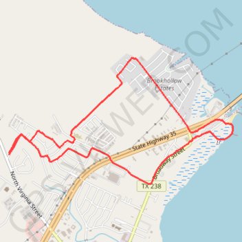
Port Lavaca Run
- Distance: 5.4 mi
- Elevation gain: 49 ft
- Maximum elevation: 33 ft
- Elevation loss: 49 ft
- Minimum elevation: 0 ft
- Moving time: 47 m 52 s
- Moving speed: 6.8 mph
- Maximum speed: 9.8 mph
- Total time: 48 m 59 s
- Global speed: 6.6 mph
Interactive trail map
Trail profile
- Distance: 5.4 mi
- Elevation gain: 49 ft
- Maximum elevation: 33 ft
- Elevation loss: 49 ft
- Minimum elevation: 0 ft
- Moving time: 47 m 52 s
- Moving speed: 6.8 mph
- Maximum speed: 9.8 mph
- Total time: 48 m 59 s
- Global speed: 6.6 mph
About this trail
Name: Port Lavaca Run trail, distance, elevation, map, profile, GPS track
Start: 147, Oakglen Drive, Port Lavaca, Calhoun County, Texas, 77979, United States (28.63481 -96.64141)
End: 135, Oakglen Drive, Port Lavaca, Calhoun County, Texas, 77979, United States (28.63464 -96.64142)
Coordinates: 28.63112 -96.64142 28.64610 -96.61115
Topography: Calhoun County topographic map, elevation, terrain
Other hiking, mountain biking, running and outdoor activity trails
Click on a trail to view its statistics, map and profile.
Port Lavaca
United States > Texas > Calhoun County > Port Lavaca
Run
Distance: 5.2 mi • Elevation gain: 128 ft • Maximum elevation: 33 ft