Thank you for supporting this site ❤️
Make a donation
Make a donation
Gear up for your next adventure:
As an Amazon Associate, this site earns from qualifying purchases at no extra cost to you.
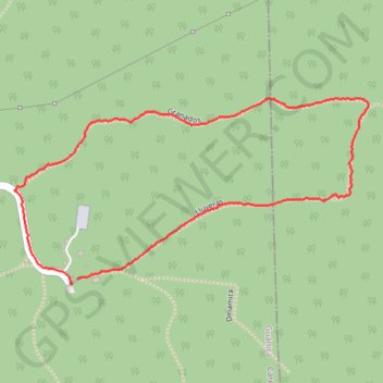
Lluveras and Granados loop
- Distance: 1.6 mi
- Elevation gain: 203 ft
- Maximum elevation: 676 ft
- Elevation loss: 207 ft
- Minimum elevation: 495 ft
- Moving time: 28 m 36 s
- Moving speed: 3.3 mph
- Maximum speed: 7.4 mph
- Total time: 29 m 5 s
- Global speed: 3.3 mph
Interactive trail map
Thank you for supporting this site ❤️
Make a donation
Make a donation
Gear up for your next adventure:
As an Amazon Associate, this site earns from qualifying purchases at no extra cost to you.
Trail profile
- Distance: 1.6 mi
- Elevation gain: 203 ft
- Maximum elevation: 676 ft
- Elevation loss: 207 ft
- Minimum elevation: 495 ft
- Moving time: 28 m 36 s
- Moving speed: 3.3 mph
- Maximum speed: 7.4 mph
- Total time: 29 m 5 s
- Global speed: 3.3 mph
Thank you for supporting this site ❤️
Make a donation
Make a donation
Gear up for your next adventure:
As an Amazon Associate, this site earns from qualifying purchases at no extra cost to you.
About this trail
Name: Lluveras and Granados loop trail, distance, elevation, map, profile, GPS track
Start: Lluveras, Carenero, Guánica, Puerto Rico, 00653, United States (17.97166 -66.86849)
Coordinates: 17.97153 -66.87009 17.97603 -66.86108
Topography: Guánica topographic map, elevation, terrain
Thank you for supporting this site ❤️
Make a donation
Make a donation
Gear up for your next adventure:
As an Amazon Associate, this site earns from qualifying purchases at no extra cost to you.