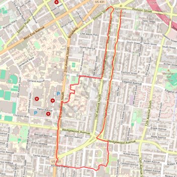
Loop Run - Running - Nashville, TN
Lunch Run
- Distance: 3.7 mi
- Elevation gain: 157 ft
- Maximum elevation: 636 ft
- Elevation loss: 177 ft
- Minimum elevation: 518 ft
- Moving time: 45 m 52 s
- Moving speed: 4.8 mph
- Maximum speed: 11.1 mph
- Total time: 45 m 52 s
- Global speed: 4.8 mph
Interactive trail map
Trail profile
- Distance: 3.7 mi
- Elevation gain: 157 ft
- Maximum elevation: 636 ft
- Elevation loss: 177 ft
- Minimum elevation: 518 ft
- Moving time: 45 m 52 s
- Moving speed: 4.8 mph
- Maximum speed: 11.1 mph
- Total time: 45 m 52 s
- Global speed: 4.8 mph
About this trail
Name: Loop Run - Running - Nashville, TN trail, distance, elevation, map, profile, GPS track
Coordinates: 36.13268 -86.80121 36.15198 -86.79161
Topography: Nashville-Davidson topographic map, elevation, terrain
Other hiking, mountain biking, running and outdoor activity trails
Click on a trail to view its statistics, map and profile.
Gmaps Pedometer Route
United States > Kentucky > Fulton County > Hickman
Distance: 312.5 mi • Elevation gain: 13,793 ft • Maximum elevation: 1,942 ft