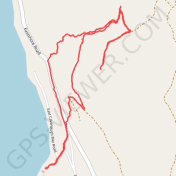
Cougar Rock Trail
- Distance: 2.7 mi
- Elevation gain: 751 ft
- Maximum elevation: 3,159 ft
- Elevation loss: 741 ft
- Minimum elevation: 2,480 ft
- Moving time: 1 h 6 m
- Moving speed: 2.5 mph
- Maximum speed: 6.3 mph
- Total time: 1 h 13 m
- Global speed: 2.3 mph
Interactive trail map
Trail profile
- Distance: 2.7 mi
- Elevation gain: 751 ft
- Maximum elevation: 3,159 ft
- Elevation loss: 741 ft
- Minimum elevation: 2,480 ft
- Moving time: 1 h 6 m
- Moving speed: 2.5 mph
- Maximum speed: 6.3 mph
- Total time: 1 h 13 m
- Global speed: 2.3 mph
About this trail
Name: Cougar Rock Trail trail, distance, elevation, map, profile, GPS track
Start: 138, East Cavanaugh Bay Road, Bonner County, Idaho, 83821, United States (48.52475 -116.82246)
End: 138, East Cavanaugh Bay Road, Bonner County, Idaho, 83821, United States (48.52480 -116.82233)
Coordinates: 48.52475 -116.82246 48.53475 -116.81450
Topography: Bonner County topographic map, elevation, terrain