Evening hike at Tuffy's Trail
- Distance: 2.6 mi
- Elevation gain: 59 ft
- Maximum elevation: 1,916 ft
- Elevation loss: 59 ft
- Minimum elevation: 1,890 ft
- Moving time: 44 m 25 s
- Moving speed: 3.5 mph
- Maximum speed: 9.1 mph
- Total time: 46 m 31 s
- Global speed: 3.3 mph
Interactive trail map
Trail profile
- Distance: 2.6 mi
- Elevation gain: 59 ft
- Maximum elevation: 1,916 ft
- Elevation loss: 59 ft
- Minimum elevation: 1,890 ft
- Moving time: 44 m 25 s
- Moving speed: 3.5 mph
- Maximum speed: 9.1 mph
- Total time: 46 m 31 s
- Global speed: 3.3 mph
About this trail
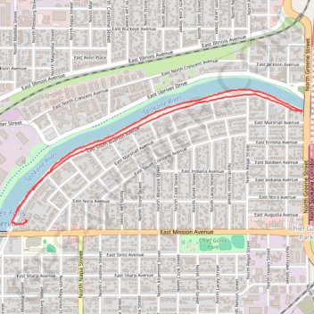
Name: Evening hike at Tuffy's Trail trail, distance, elevation, map, profile, GPS track
Coordinates: 47.67223 -117.38646 47.67921 -117.36409
Topography: Spokane topographic map, elevation, terrain
Other hiking, mountain biking, running and outdoor activity trails
Click on a trail to view its statistics, map and profile.
Tuffy's Trail hike
United States > Washington > Spokane County > Spokane
Evening hike
Distance: 2.6 mi • Elevation gain: 62 ft • Maximum elevation: 1,916 ft