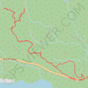
Teodoro Trail
- Distance: 5.1 mi
- Elevation gain: 1,342 ft
- Maximum elevation: 1,158 ft
- Elevation loss: 1,342 ft
- Minimum elevation: 259 ft
- Moving time: 2 h 39 m
- Moving speed: 1.9 mph
- Maximum speed: 5.1 mph
- Total time: 3 h 5 m
- Global speed: 1.7 mph
Interactive trail map
Trail profile
- Distance: 5.1 mi
- Elevation gain: 1,342 ft
- Maximum elevation: 1,158 ft
- Elevation loss: 1,342 ft
- Minimum elevation: 259 ft
- Moving time: 2 h 39 m
- Moving speed: 1.9 mph
- Maximum speed: 5.1 mph
- Total time: 3 h 5 m
- Global speed: 1.7 mph
About this trail
Name: Teodoro Trail trail, distance, elevation, map, profile, GPS track
Coordinates: 49.27980 -125.01162 49.29357 -124.98775
Other hiking, mountain biking, running and outdoor activity trails
Click on a trail to view its statistics, map and profile.
Pacific Rim National Park - Fanny Bay
Canada > British Columbia > Alberni-Clayoquot Regional District > Area C (Long Beach)
Vancouver Island. #Bike #PacificRim #Vancouver #Pacific
Distance: 58.2 mi • Elevation gain: 4,459 ft • Maximum elevation: 843 ft