Thank you for supporting this site ❤️
Make a donation
Make a donation
Gear up for your next adventure:
As an Amazon Associate, this site earns from qualifying purchases at no extra cost to you.
Haast - Fox Glacier
Interactive trail map
Thank you for supporting this site ❤️
Make a donation
Make a donation
Gear up for your next adventure:
As an Amazon Associate, this site earns from qualifying purchases at no extra cost to you.
Trail profile
- Distance: 75.6 mi
- Elevation gain: 4,088 ft
- Maximum elevation: 633 ft
- Elevation loss: 3,615 ft
- Minimum elevation: 7 ft
Thank you for supporting this site ❤️
Make a donation
Make a donation
Gear up for your next adventure:
As an Amazon Associate, this site earns from qualifying purchases at no extra cost to you.
About this trail
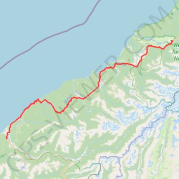
Name: Haast - Fox Glacier trail, distance, elevation, map, profile, GPS track
Coordinates: -43.88077 169.04166 -43.46270 170.01782
Thank you for supporting this site ❤️
Make a donation
Make a donation
Gear up for your next adventure:
As an Amazon Associate, this site earns from qualifying purchases at no extra cost to you.
Other hiking, mountain biking, running and outdoor activity trails
Click on a trail to view its statistics, map and profile.
Copland Track to Welcome Flat Hut
New Zealand > West Coast > Westland District
Distance: 10.9 mi • Elevation gain: 2,740 ft • Maximum elevation: 1,578 ft