Marysville Loop
Steavensons Falls Natural Features and Scenic Reserve. #Hiking #Loop #Steavensons
- Distance: 8.4 mi
- Elevation gain: 1,929 ft
- Maximum elevation: 2,746 ft
- Elevation loss: 1,936 ft
- Minimum elevation: 1,398 ft
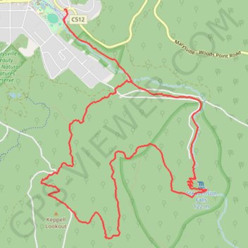
Interactive trail map
Trail profile
- Distance: 8.4 mi
- Elevation gain: 1,929 ft
- Maximum elevation: 2,746 ft
- Elevation loss: 1,936 ft
- Minimum elevation: 1,398 ft
About this trail
Name: Marysville Loop trail, distance, elevation, map, profile, GPS track
Coordinates: -37.53963 145.74935 -37.51150 145.77494
Other hiking, mountain biking, running and outdoor activity trails
Click on a trail to view its statistics, map and profile.
Tallarook - Eildon - Hurstbridge
Australia > Victoria > Tallarook
#Bike
Distance: 173.2 mi • Elevation gain: 16,066 ft • Maximum elevation: 2,848 ft
Steavenson's Falls, Keppel Lookout, Michaeldene Trail loop
Australia > Victoria > Marysville
Distance: 12.3 mi • Elevation gain: 2,277 ft • Maximum elevation: 2,746 ft