Make a donation
Gear up for your next adventure:
As an Amazon Associate, this site earns from qualifying purchases at no extra cost to you.
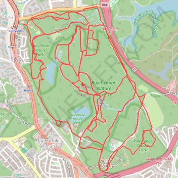
Bukit Timah Nature Reserve
Interactive trail map
Make a donation
Gear up for your next adventure:
As an Amazon Associate, this site earns from qualifying purchases at no extra cost to you.
Trail profile
- Distance: 19.0 mi
- Elevation gain: 2,976 ft
- Maximum elevation: 548 ft
- Elevation loss: 2,982 ft
- Minimum elevation: 92 ft
Make a donation
Gear up for your next adventure:
As an Amazon Associate, this site earns from qualifying purchases at no extra cost to you.
About this trail
Name: Bukit Timah Nature Reserve trail, distance, elevation, map, profile, GPS track
Start: Hindhede Drive, Bukit Panjang, Northwest, Singapore, 589242, Singapore (1.34758 103.77640)
End: Hindhede Drive, Bukit Panjang, Northwest, Singapore, 589242, Singapore (1.34740 103.77628)
Coordinates: 1.34285 103.76835 1.36514 103.78645
Make a donation
Gear up for your next adventure:
As an Amazon Associate, this site earns from qualifying purchases at no extra cost to you.
Other hiking, mountain biking, running and outdoor activity trails
Click on a trail to view its statistics, map and profile.
Bukit Timah Hill - MacRitchie Reservoir
Distance: 9.2 mi • Elevation gain: 951 ft • Maximum elevation: 548 ft
The Green Corridor - Singapore
Distance: 13.8 mi • Elevation gain: 548 ft • Maximum elevation: 144 ft
Tree Top Walk & Bukit Timah Hill in Central Catchment Nature Reserve
Distance: 8.8 mi • Elevation gain: 1,047 ft • Maximum elevation: 545 ft
Directions from Duck Tour Ramp to Marina Boulevard, Singapore
Distance: 65.5 mi • Elevation gain: 2,664 ft • Maximum elevation: 167 ft
Make a donation
Gear up for your next adventure:
As an Amazon Associate, this site earns from qualifying purchases at no extra cost to you.