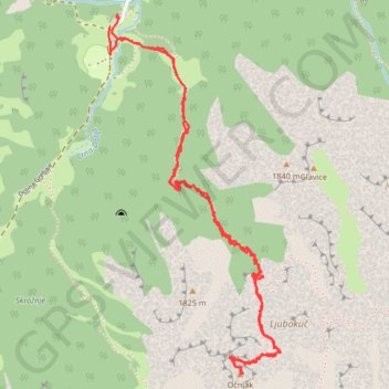
Očnjak
- Distance: 4.1 mi
- Elevation gain: 3,547 ft
- Maximum elevation: 6,647 ft
- Elevation loss: 3,550 ft
- Minimum elevation: 3,753 ft
- Moving time: 2 h 57 m
- Moving speed: 1.4 mph
- Maximum speed: 9.4 mph
- Total time: 8 h 3 m
- Global speed: 0.5 mph
Interactive trail map
Trail profile
- Distance: 4.1 mi
- Elevation gain: 3,547 ft
- Maximum elevation: 6,647 ft
- Elevation loss: 3,550 ft
- Minimum elevation: 3,753 ft
- Moving time: 2 h 57 m
- Moving speed: 1.4 mph
- Maximum speed: 9.4 mph
- Total time: 8 h 3 m
- Global speed: 0.5 mph
About this trail
Name: Očnjak trail, distance, elevation, map, profile, GPS track
Start: Dolina Grebaje, Škala, Gusinje Municipality, Montenegro (42.52153 19.78639)
End: Dolina Grebaje, Škala, Gusinje Municipality, Montenegro (42.52189 19.78674)
Coordinates: 42.50783 19.78630 42.52202 19.79549
Other hiking, mountain biking, running and outdoor activity trails
Click on a trail to view its statistics, map and profile.
2022_Yu
Slovenia > Ajdovščina > Žapuže
Distance: 1,526.9 mi • Elevation gain: 105,144 ft • Maximum elevation: 6,398 ft