Thank you for supporting this site ❤️
Make a donation
Make a donation
Gear up for your next adventure:
As an Amazon Associate, this site earns from qualifying purchases at no extra cost to you.
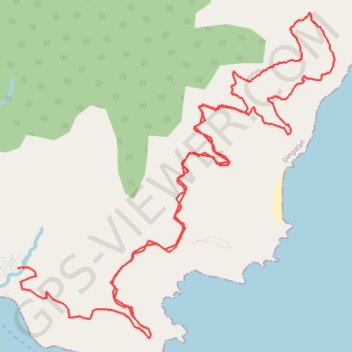
Dingalan-San Luis
- Distance: 14.1 mi
- Elevation gain: 3,527 ft
- Maximum elevation: 1,115 ft
- Elevation loss: 4,167 ft
- Minimum elevation: 85 ft
- Moving time: 2 h 51 m
- Moving speed: 4.9 mph
- Maximum speed: 28.0 mph
- Total time: 5 h 3 m
- Global speed: 2.8 mph
Interactive trail map
Thank you for supporting this site ❤️
Make a donation
Make a donation
Gear up for your next adventure:
As an Amazon Associate, this site earns from qualifying purchases at no extra cost to you.
Trail profile
- Distance: 14.1 mi
- Elevation gain: 3,527 ft
- Maximum elevation: 1,115 ft
- Elevation loss: 4,167 ft
- Minimum elevation: 85 ft
- Moving time: 2 h 51 m
- Moving speed: 4.9 mph
- Maximum speed: 28.0 mph
- Total time: 5 h 3 m
- Global speed: 2.8 mph
Thank you for supporting this site ❤️
Make a donation
Make a donation
Gear up for your next adventure:
As an Amazon Associate, this site earns from qualifying purchases at no extra cost to you.
About this trail
Name: Dingalan-San Luis trail, distance, elevation, map, profile, GPS track
Coordinates: 15.37606 121.41186 15.41532 121.45154
Thank you for supporting this site ❤️
Make a donation
Make a donation
Gear up for your next adventure:
As an Amazon Associate, this site earns from qualifying purchases at no extra cost to you.