Thank you for supporting this site ❤️
Make a donation
Make a donation
Gear up for your next adventure:
As an Amazon Associate, this site earns from qualifying purchases at no extra cost to you.
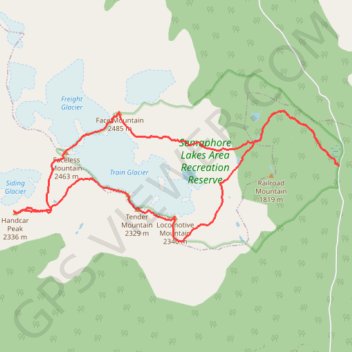
Train-Glacier-5-Peaks-Loop-with-a-Handcar-Mnt-Detour
- Distance: 11.8 mi
- Elevation gain: 7,044 ft
- Maximum elevation: 8,123 ft
- Elevation loss: 7,047 ft
- Minimum elevation: 4,419 ft
Interactive trail map
Thank you for supporting this site ❤️
Make a donation
Make a donation
Gear up for your next adventure:
As an Amazon Associate, this site earns from qualifying purchases at no extra cost to you.
Trail profile
- Distance: 11.8 mi
- Elevation gain: 7,044 ft
- Maximum elevation: 8,123 ft
- Elevation loss: 7,047 ft
- Minimum elevation: 4,419 ft
Thank you for supporting this site ❤️
Make a donation
Make a donation
Gear up for your next adventure:
As an Amazon Associate, this site earns from qualifying purchases at no extra cost to you.
About this trail
Name: Train-Glacier-5-Peaks-Loop-with-a-Handcar-Mnt-Detour trail, distance, elevation, map, profile, GPS track
Coordinates: 50.57870 -123.09858 50.59927 -123.01769
Thank you for supporting this site ❤️
Make a donation
Make a donation
Gear up for your next adventure:
As an Amazon Associate, this site earns from qualifying purchases at no extra cost to you.
Other hiking, mountain biking, running and outdoor activity trails
Click on a trail to view its statistics, map and profile.