Make a donation
Gear up for your next adventure:
As an Amazon Associate, this site earns from qualifying purchases at no extra cost to you.
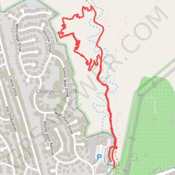
Harmon Canyon Preserve
- Distance: 3.3 mi
- Elevation gain: 449 ft
- Maximum elevation: 715 ft
- Elevation loss: 449 ft
- Minimum elevation: 417 ft
- Moving time: 1 h 17 m
- Moving speed: 2.6 mph
- Maximum speed: 4.2 mph
- Total time: 1 h 58 m
- Global speed: 1.7 mph
Interactive trail map
Make a donation
Gear up for your next adventure:
As an Amazon Associate, this site earns from qualifying purchases at no extra cost to you.
Trail profile
- Distance: 3.3 mi
- Elevation gain: 449 ft
- Maximum elevation: 715 ft
- Elevation loss: 449 ft
- Minimum elevation: 417 ft
- Moving time: 1 h 17 m
- Moving speed: 2.6 mph
- Maximum speed: 4.2 mph
- Total time: 1 h 58 m
- Global speed: 1.7 mph
Make a donation
Gear up for your next adventure:
As an Amazon Associate, this site earns from qualifying purchases at no extra cost to you.
About this trail
Name: Harmon Canyon Preserve trail, distance, elevation, map, profile, GPS track
Start: Harmon Canyon Road, Ventura County, California, 93004, United States (34.28939 -119.19767)
End: Harmon Canyon Road, Ventura County, California, 93004, United States (34.28893 -119.19744)
Coordinates: 34.28893 -119.20242 34.30088 -119.19715
Topography: Ventura County topographic map, elevation, terrain
Make a donation
Gear up for your next adventure:
As an Amazon Associate, this site earns from qualifying purchases at no extra cost to you.
Other hiking, mountain biking, running and outdoor activity trails
Click on a trail to view its statistics, map and profile.
Harmon Canyon Preserve
United States > California > Ventura County
Morning Run
Distance: 4.0 mi • Elevation gain: 633 ft • Maximum elevation: 951 ft