Thank you for supporting this site ❤️
Make a donation
Make a donation
Gear up for your next adventure:
As an Amazon Associate, this site earns from qualifying purchases at no extra cost to you.
Saluda Riverwalk
Interactive trail map
Thank you for supporting this site ❤️
Make a donation
Make a donation
Gear up for your next adventure:
As an Amazon Associate, this site earns from qualifying purchases at no extra cost to you.
Trail profile
- Distance: 3.4 mi
- Elevation gain: 144 ft
- Maximum elevation: 167 ft
- Elevation loss: 144 ft
- Minimum elevation: 135 ft
- Moving time: 39 m 27 s
- Moving speed: 5.2 mph
- Maximum speed: 9.5 mph
- Total time: 46 m 47 s
- Global speed: 4.4 mph
Thank you for supporting this site ❤️
Make a donation
Make a donation
Gear up for your next adventure:
As an Amazon Associate, this site earns from qualifying purchases at no extra cost to you.
About this trail
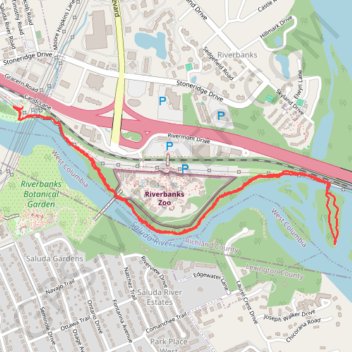
Name: Saluda Riverwalk trail, distance, elevation, map, profile, GPS track
Coordinates: 34.00640 -81.08233 34.01334 -81.06254
Topography: Columbia topographic map, elevation, terrain
Thank you for supporting this site ❤️
Make a donation
Make a donation
Gear up for your next adventure:
As an Amazon Associate, this site earns from qualifying purchases at no extra cost to you.