Import a GPX file
👉 Easily get elevation data in JSON, GeoTIFF and KML formats using Elevation API
Thank you for supporting this site ❤️
Make a donation

Gear up for your next adventure:

As an Amazon Associate, this site earns from qualifying purchases at no extra cost to you.

Hot Springs Mountain

Hike to Hot Springs Mountain via Sukat Road and Hot Springs Mountain Road in the Los Coyotes Cahuilla Cupeno Band. #Hiking #Nature #Forest #Mountain

  • Distance: 5.0 mi
  • Elevation gain: 2,116 ft
  • Maximum elevation: 6,476 ft
  • Elevation loss: 223 ft
  • Minimum elevation: 4,573 ft

Interactive trail map
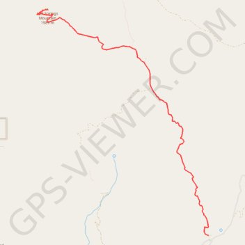
Gear up for your next adventure:

As an Amazon Associate, this site earns from qualifying purchases at no extra cost to you.

Trail profile

👉 Easily get elevation data in JSON, GeoTIFF and KML formats using Elevation API
Thank you for supporting this site ❤️
Make a donation

Gear up for your next adventure:

As an Amazon Associate, this site earns from qualifying purchases at no extra cost to you.

About this trail

Name: Hot Springs Mountain trail, distance, elevation, map, profile, GPS track

Start: Sukat Road, San Diego County, California, United States (33.27288 -116.54380)

End: Hot Springs Mountain Road, San Diego County, California, United States (33.31522 -116.57983)

Coordinates: 33.27288 -116.58217 33.31522 -116.54380

Topography: San Diego County topographic map, elevation, terrain

👉 Easily get elevation data in JSON, GeoTIFF and KML formats using Elevation API
Thank you for supporting this site ❤️
Make a donation

Gear up for your next adventure:

As an Amazon Associate, this site earns from qualifying purchases at no extra cost to you.