Devil's Chair
Hike to Devil's Chair via Devil's Chair Trail in Angeles National Forest. #Hiking #Mountain #Nature #Forest #Angeles
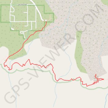
- Distance: 3.7 mi
- Elevation gain: 1,293 ft
- Maximum elevation: 5,351 ft
- Elevation loss: 1,204 ft
- Minimum elevation: 4,777 ft
- Moving time: 35 m 37 s
- Moving speed: 6.3 mph
- Maximum speed: 7.4 mph
- Total time: 35 m 37 s
- Global speed: 6.3 mph
Interactive trail map
Trail profile
- Distance: 3.7 mi
- Elevation gain: 1,293 ft
- Maximum elevation: 5,351 ft
- Elevation loss: 1,204 ft
- Minimum elevation: 4,777 ft
- Moving time: 35 m 37 s
- Moving speed: 6.3 mph
- Maximum speed: 7.4 mph
- Total time: 35 m 37 s
- Global speed: 6.3 mph
About this trail
Name: Devil's Chair trail, distance, elevation, map, profile, GPS track
Start: Devil's Chair Trail, Los Angeles County, California, United States (34.41366 -117.85855)
End: Devil's Chair Trail, Los Angeles County, California, United States (34.40239 -117.84567)
Coordinates: 34.39978 -117.86963 34.41366 -117.84360
Topography: Los Angeles County topographic map, elevation, terrain