Thank you for supporting this site ❤️
Make a donation
Make a donation
Gear up for your next adventure:
As an Amazon Associate, this site earns from qualifying purchases at no extra cost to you.
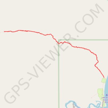
Dumpling Mountain Trail
- Distance: 4.7 mi
- Elevation gain: 1,486 ft
- Maximum elevation: 1,535 ft
- Elevation loss: 1,490 ft
- Minimum elevation: 62 ft
- Moving time: 2 h 17 m
- Moving speed: 2.1 mph
- Maximum speed: 3.3 mph
- Total time: 2 h 51 m
- Global speed: 1.7 mph
Interactive trail map
Thank you for supporting this site ❤️
Make a donation
Make a donation
Gear up for your next adventure:
As an Amazon Associate, this site earns from qualifying purchases at no extra cost to you.
Trail profile
- Distance: 4.7 mi
- Elevation gain: 1,486 ft
- Maximum elevation: 1,535 ft
- Elevation loss: 1,490 ft
- Minimum elevation: 62 ft
- Moving time: 2 h 17 m
- Moving speed: 2.1 mph
- Maximum speed: 3.3 mph
- Total time: 2 h 51 m
- Global speed: 1.7 mph
Thank you for supporting this site ❤️
Make a donation
Make a donation
Gear up for your next adventure:
As an Amazon Associate, this site earns from qualifying purchases at no extra cost to you.
About this trail
Name: Dumpling Mountain Trail trail, distance, elevation, map, profile, GPS track
Start: Dumpling Mountain Trail, Lake and Peninsula, Alaska, United States (58.56105 -155.77814)
End: Dumpling Mountain Trail, Lake and Peninsula, Alaska, United States (58.56080 -155.77801)
Coordinates: 58.56080 -155.82312 58.57196 -155.77801
Topography: Lake and Peninsula topographic map, elevation, terrain
Thank you for supporting this site ❤️
Make a donation
Make a donation
Gear up for your next adventure:
As an Amazon Associate, this site earns from qualifying purchases at no extra cost to you.