Thank you for supporting this site ❤️
Make a donation
Make a donation
Gear up for your next adventure:
As an Amazon Associate, this site earns from qualifying purchases at no extra cost to you.
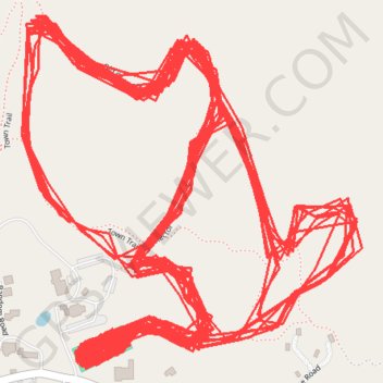
Marlboro Nordic Ski Club Trails
- Distance: 30.9 mi
- Elevation gain: 3,406 ft
- Maximum elevation: 1,824 ft
- Elevation loss: 3,406 ft
- Minimum elevation: 1,608 ft
- Moving time: 4 h 37 s
- Moving speed: 7.7 mph
- Maximum speed: 30.4 mph
- Total time: 4 h 21 m
- Global speed: 7.1 mph
Interactive trail map
Thank you for supporting this site ❤️
Make a donation
Make a donation
Gear up for your next adventure:
As an Amazon Associate, this site earns from qualifying purchases at no extra cost to you.
Trail profile
- Distance: 30.9 mi
- Elevation gain: 3,406 ft
- Maximum elevation: 1,824 ft
- Elevation loss: 3,406 ft
- Minimum elevation: 1,608 ft
- Moving time: 4 h 37 s
- Moving speed: 7.7 mph
- Maximum speed: 30.4 mph
- Total time: 4 h 21 m
- Global speed: 7.1 mph
Thank you for supporting this site ❤️
Make a donation
Make a donation
Gear up for your next adventure:
As an Amazon Associate, this site earns from qualifying purchases at no extra cost to you.
About this trail
Name: Marlboro Nordic Ski Club Trails trail, distance, elevation, map, profile, GPS track
End: South Road, Marlboro, Windham County, Vermont, 05344, United States (42.83897 -72.73279)
Coordinates: 42.83876 -72.73491 42.84522 -72.72641
Topography: Windham County topographic map, elevation, terrain
Thank you for supporting this site ❤️
Make a donation
Make a donation
Gear up for your next adventure:
As an Amazon Associate, this site earns from qualifying purchases at no extra cost to you.