Make a donation
Gear up for your next adventure:
As an Amazon Associate, this site earns from qualifying purchases at no extra cost to you.
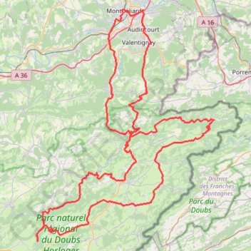
Parking Velotte, Montbéliard - Montbéliard
- Distance: 110.9 mi
- Elevation gain: 9,459 ft
- Maximum elevation: 2,910 ft
- Elevation loss: 9,459 ft
- Minimum elevation: 1,020 ft
Interactive trail map
Make a donation
Gear up for your next adventure:
As an Amazon Associate, this site earns from qualifying purchases at no extra cost to you.
Trail profile
- Distance: 110.9 mi
- Elevation gain: 9,459 ft
- Maximum elevation: 2,910 ft
- Elevation loss: 9,459 ft
- Minimum elevation: 1,020 ft
Make a donation
Gear up for your next adventure:
As an Amazon Associate, this site earns from qualifying purchases at no extra cost to you.
About this trail
Name: Parking Velotte, Montbéliard - Montbéliard trail, distance, elevation, map, profile, GPS track
Coordinates: 47.15787 6.60224 47.51188 7.00240
Make a donation
Gear up for your next adventure:
As an Amazon Associate, this site earns from qualifying purchases at no extra cost to you.
Other hiking, mountain biking, running and outdoor activity trails
Click on a trail to view its statistics, map and profile.
Riethoven naar Oostenrijk
Netherlands > North Brabant > Riethoven > Eind
Distance: 573.0 mi • Elevation gain: 44,715 ft • Maximum elevation: 6,224 ft
PT23DS2 Lörrach → Cadaqués
Germany > Baden-Württemberg > Landkreis Lörrach > Lörrach (Kernstadt)
Distance: 652.9 mi • Elevation gain: 43,077 ft • Maximum elevation: 4,938 ft