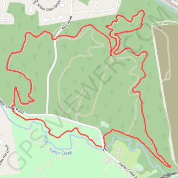
Grotpeter Loop Trail in Castlewood State Park
The Grotpeter Loop Trail offers a moderately challenging hike with scenic segments that include shaded woodland paths and sections along Kiefer Creek. The trail features a mix of gradual climbs and rocky descents, notably Cardiac Hill, which adds intensity and appeal for more adventurous hikers and mountain bikers. Although it lacks expansive vistas, the trail’s natural beauty, tranquil creekside paths, and potential wildlife sightings provide a serene, engaging experience close to St. Louis. #Hiking #Loop #Forest #Nature
- Distance: 4.5 mi
- Elevation gain: 377 ft
- Maximum elevation: 630 ft
- Elevation loss: 374 ft
- Minimum elevation: 417 ft
- Moving time: 1 h 38 m
- Moving speed: 2.7 mph
- Maximum speed: 7.1 mph
- Total time: 1 h 41 m
- Global speed: 2.6 mph
Interactive trail map
Trail profile
- Distance: 4.5 mi
- Elevation gain: 377 ft
- Maximum elevation: 630 ft
- Elevation loss: 374 ft
- Minimum elevation: 417 ft
- Moving time: 1 h 38 m
- Moving speed: 2.7 mph
- Maximum speed: 7.1 mph
- Total time: 1 h 41 m
- Global speed: 2.6 mph
About this trail
Name: Grotpeter Loop Trail in Castlewood State Park trail, distance, elevation, map, profile, GPS track
Start: Grotpeter Trail, Saint Louis County, Missouri, 63021, United States (38.55090 -90.54079)
End: 1501, Kiefer Creek Road, Saint Louis County, Missouri, 63021, United States (38.55076 -90.54053)
Coordinates: 38.54936 -90.55001 38.56126 -90.53406
Topography: Saint Louis County topographic map, elevation, terrain
Other hiking, mountain biking, running and outdoor activity trails
Click on a trail to view its statistics, map and profile.
Riverscene Trail Loop in Castlewood State Park
United States > Missouri > Saint Louis County
The Riverscene Trail Loop offers a variety of scenic landscapes, ranging from rugged cliffs with expansive river valley views to tranquil riverside paths shaded by towering trees. The trail takes hikers along the edge of the Meramec River, providing several opportunities to take in panoramic vistas of the…
Distance: 3.4 mi • Elevation gain: 312 ft • Maximum elevation: 587 ft
Riverscene Loop Trail in Castlewood State Park
United States > Missouri > Saint Louis County
The Riverscene Loop Trail in Castlewood State Park, located near St. Louis, Missouri, is renowned for its stunning vistas of the Meramec River valley and its surrounding landscapes. Hikers can enjoy panoramic views from the bluffs, traverse diverse terrains including forested areas and rocky outcrops, and…
Distance: 3.5 mi • Elevation gain: 315 ft • Maximum elevation: 587 ft
Lone Wolf Loop Trail in Castlewood State Park
United States > Missouri > Saint Louis County
The Lone Wolf Loop Trail offers a captivating mix of natural beauty and rich history. As you hike, you'll enjoy sweeping views of the Meramec River valley from the bluffs, followed by a descent through shaded forested areas with fern-covered hillsides. The trail also takes you alongside Kiefer Creek, providing…
Distance: 1.7 mi • Elevation gain: 279 ft • Maximum elevation: 620 ft