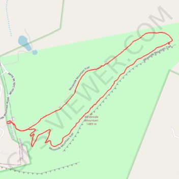
Whiteside Mountain Loop Trail in Nantahala National Forest
The Whiteside Mountain Loop Trail offers a striking blend of natural beauty and rich history in North Carolina's Nantahala National Forest. As you hike, the views are dominated by towering cliffs that drop over 750 feet to the valley below, offering sweeping panoramas of the surrounding mountain ranges, including Blackrock and Terrapin. Along the route, you'll encounter wildflowers, and the area’s geological features, such as the quartz-streaked rock faces, add to its visual charm. Additionally, the mountain’s historical significance, including its role in early 20th-century rescues and the reintroduction of peregrine falcons, makes this trail a multifaceted hiking experience. #Hiking #Loop #Cliff #Forest #Nature
- Distance: 2.1 mi
- Elevation gain: 764 ft
- Maximum elevation: 4,806 ft
- Elevation loss: 768 ft
- Minimum elevation: 4,380 ft
- Moving time: 54 m 17 s
- Moving speed: 2.3 mph
- Maximum speed: 5.4 mph
- Total time: 1 h 5 m
- Global speed: 1.9 mph
Interactive trail map
Trail profile
- Distance: 2.1 mi
- Elevation gain: 764 ft
- Maximum elevation: 4,806 ft
- Elevation loss: 768 ft
- Minimum elevation: 4,380 ft
- Moving time: 54 m 17 s
- Moving speed: 2.3 mph
- Maximum speed: 5.4 mph
- Total time: 1 h 5 m
- Global speed: 1.9 mph
About this trail
Name: Whiteside Mountain Loop Trail in Nantahala National Forest trail, distance, elevation, map, profile, GPS track
Coordinates: 35.07896 -83.14429 35.08568 -83.13239
Topography: Macon County topographic map, elevation, terrain
Other hiking, mountain biking, running and outdoor activity trails
Click on a trail to view its statistics, map and profile.
Whiteside Mountain Loop Trail in Nantahala National Forest
United States > North Carolina > Macon County
The Whiteside Mountain Loop Trail in the Nantahala National Forest offers an enjoyable yet moderately challenging hiking experience. As you ascend through a mix of hardwood forests, the trail leads to spectacular views over the surrounding mountains, including the expansive Nantahala National Forest and parts…
Distance: 2.1 mi • Elevation gain: 741 ft • Maximum elevation: 4,806 ft
Great Smoky Mountains Appalachian Trail
United States > North Carolina > Clay County
Hike through Great Smoky Mountains along Appalachian Trail via Standing Indian, Ridgepole Mountain, Yellow Bald, Wine Spring Bald, Copper Ridge Bald, Cheoah Bald, Wauchecha Bald, Fontana Dam, Thunderhead Mountain, Clingmans Dome, Mount Kephart and Mount Guyot. #Hiking #Mountain #Nature #Forest #Lake…
Distance: 144.0 mi • Elevation gain: 29,111 ft • Maximum elevation: 6,604 ft