Rocky Mount Tar River and Parks
- Distance: 4.0 mi
- Elevation gain: 105 ft
- Maximum elevation: 112 ft
- Elevation loss: 105 ft
- Minimum elevation: 66 ft
- Moving time: 1 h 19 m
- Moving speed: 3.0 mph
- Maximum speed: 4.7 mph
- Total time: 1 h 23 m
- Global speed: 2.9 mph
Interactive trail map
Trail profile
- Distance: 4.0 mi
- Elevation gain: 105 ft
- Maximum elevation: 112 ft
- Elevation loss: 105 ft
- Minimum elevation: 66 ft
- Moving time: 1 h 19 m
- Moving speed: 3.0 mph
- Maximum speed: 4.7 mph
- Total time: 1 h 23 m
- Global speed: 2.9 mph
About this trail
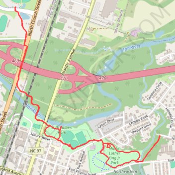
Name: Rocky Mount Tar River and Parks trail, distance, elevation, map, profile, GPS track
Coordinates: 35.95031 -77.79075 35.96426 -77.77531
Topography: Rocky Mount topographic map, elevation, terrain
Other hiking, mountain biking, running and outdoor activity trails
Click on a trail to view its statistics, map and profile.
Rocky Mount Greenway: Battle Park to Martin Luther King Park
United States > North Carolina > Nash County > Rocky Mount > Swelton Heights
Distance: 2.9 mi • Elevation gain: 112 ft • Maximum elevation: 121 ft