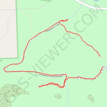
Potawatomi Trail
Pinckney State Recreation Area
- Distance: 1.7 mi
- Elevation gain: 43 ft
- Maximum elevation: 951 ft
- Elevation loss: 43 ft
- Minimum elevation: 919 ft
- Moving time: 18 m 21 s
- Moving speed: 5.6 mph
- Maximum speed: 17.4 mph
- Total time: 20 m 7 s
- Global speed: 5.1 mph
Interactive trail map
Trail profile
- Distance: 1.7 mi
- Elevation gain: 43 ft
- Maximum elevation: 951 ft
- Elevation loss: 43 ft
- Minimum elevation: 919 ft
- Moving time: 18 m 21 s
- Moving speed: 5.6 mph
- Maximum speed: 17.4 mph
- Total time: 20 m 7 s
- Global speed: 5.1 mph
About this trail
Name: Potawatomi Trail trail, distance, elevation, map, profile, GPS track
Coordinates: 42.42905 -84.01514 42.43404 -84.00537
Topography: Livingston County topographic map, elevation, terrain