Malmesbury
- Distance: 10.3 mi
- Elevation gain: 492 ft
- Maximum elevation: 335 ft
- Elevation loss: 489 ft
- Minimum elevation: 230 ft
- Moving time: 3 h 6 m
- Moving speed: 3.3 mph
- Maximum speed: 6.2 mph
- Total time: 3 h 40 m
- Global speed: 2.8 mph
Interactive trail map
Trail profile
- Distance: 10.3 mi
- Elevation gain: 492 ft
- Maximum elevation: 335 ft
- Elevation loss: 489 ft
- Minimum elevation: 230 ft
- Moving time: 3 h 6 m
- Moving speed: 3.3 mph
- Maximum speed: 6.2 mph
- Total time: 3 h 40 m
- Global speed: 2.8 mph
About this trail
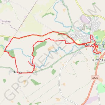
Name: Malmesbury trail, distance, elevation, map, profile, GPS track
Coordinates: 51.57204 -2.16190 51.59009 -2.09417
Other hiking, mountain biking, running and outdoor activity trails
Click on a trail to view its statistics, map and profile.
Dean2023-311
United Kingdom > England > Oxfordshire > Oxford
Distance: 192.8 mi • Elevation gain: 11,043 ft • Maximum elevation: 951 ft